
| |
 |
British Foreign Policy 1815-65 |
I am happy that you are using this web site and hope that you found it useful. Unfortunately, the cost of making this material freely available is increasing, so if you have found the site useful and would like to contribute towards its continuation, I would greatly appreciate it. Click the button to go to Paypal and make a donation.
This map has been taken from the website of Battery B, 4th U.S. Light Artillery and is reproduced here with the kind permission of 'Corporal Scott Gutzke' to whom thanks are due. This document has been copied from its primary location on The Victorian Web.
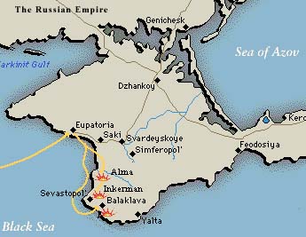
Other maps are also available:
Sevastopol
the West Coast of the Crimea
the Straits
Map of the Battle of the Alma
Map of the Battle of Inkerman
Map of the Charge of the Light Brigade
Map of the Chersonese Peninsula
Map of the Ottoman Empire
| Meet the web creator | These materials may be freely used for
non-commercial purposes in accordance with applicable statutory allowances
and distribution to students. |
Last modified
12 January, 2016
|